Agriculture Fair Walkability Map Survey
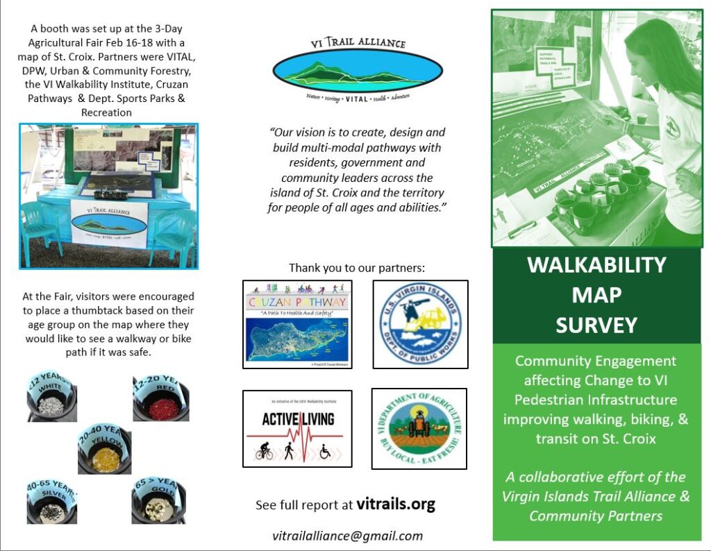
The VI Trail Alliance has been working in partnership with the walkability team on St. Croix, the Department of Public Works, the Urban and Community Forestry Program, the Cruzan Pathways Inc. and many other organizations, government offices and individuals with the interest of improving walkability and connectivity on St. Croix.
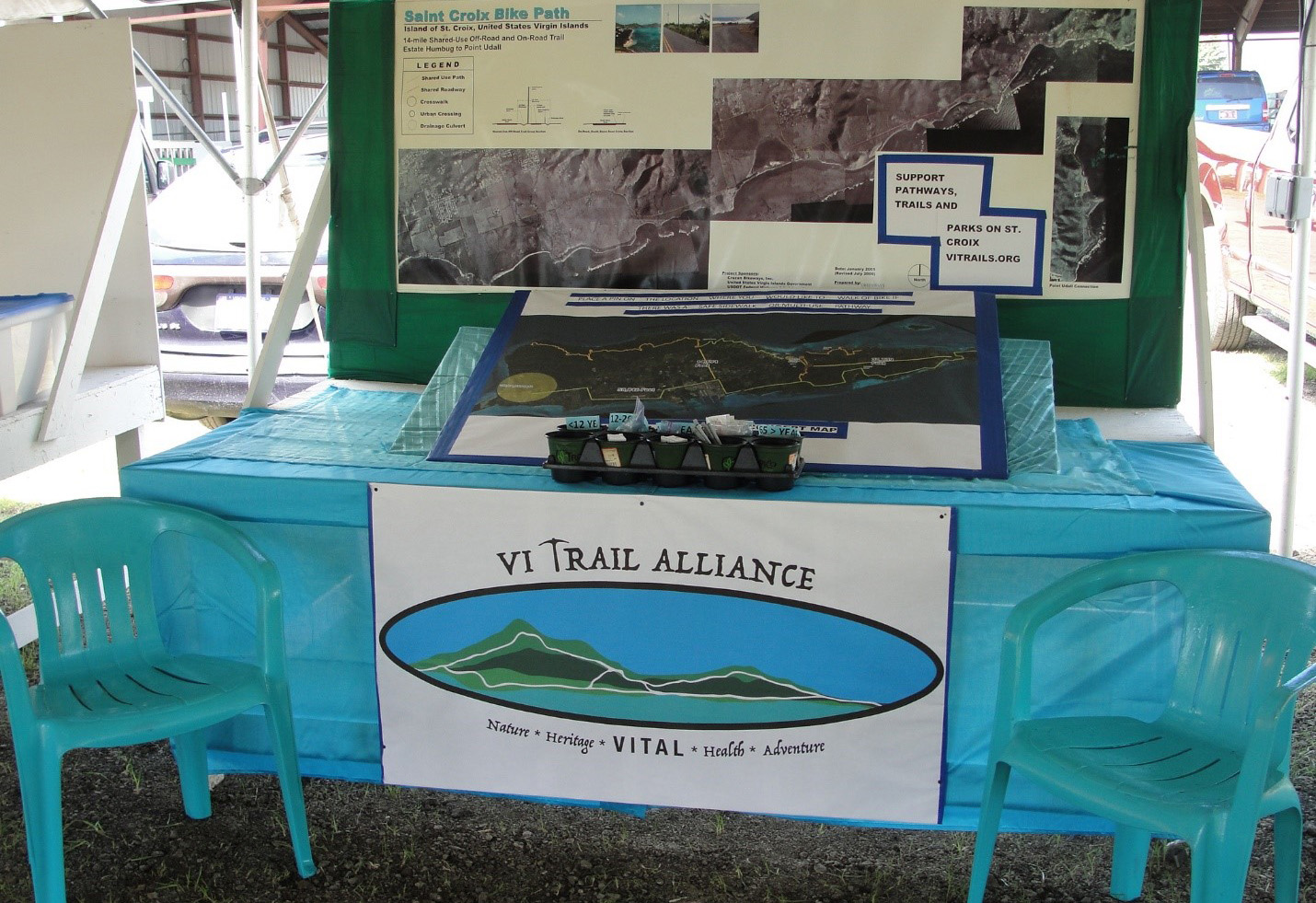
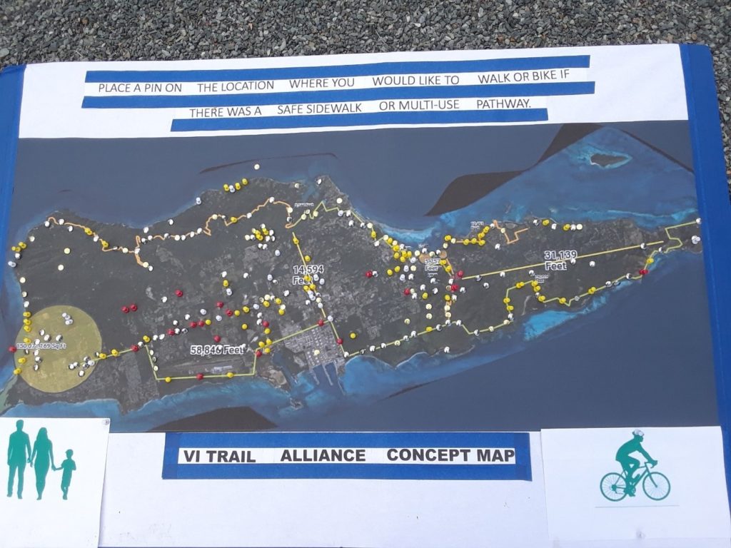
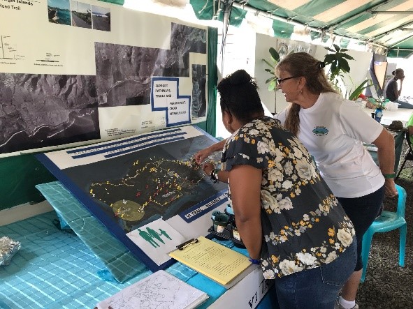
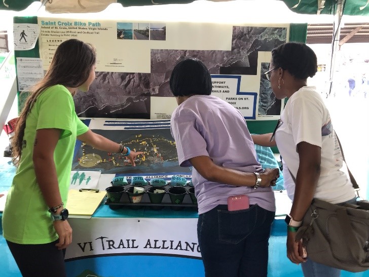
The above-mentioned organizations decided to set up a Map display and random walkability survey at the Agriculture Fair. The Agriculture Fair is known to attract large numbers of fair-goers with an estimate of 15,000 people over the three days of the event that vary in ages St. Croix and surrounding area. The survey committee chose this venue to obtain a rapid, large volume, random data collection project. It was determined to ask booth visitors one question as there are many sights and sounds to explore. It is an active environment so maintaining fair-goers attention for more than a few moments is challenging. Interested participants were instructed to choose a thumb tack that represented their age group and to push it into the map at a location where they would like to walk or bike if it was safe”.
The Map that was provided was the VITAL concept Map with pathway segments marked in color. These marked pathway segments also represented the location of many local roads that people are familiar with. The Map was monitored by project partners who assisted people to find locations if they asked but did not influence where the participants placed their pin on the map. The Map was covered during fair closure hours. A picture was taken of the map prior to starting and at the end of the survey. The Map was displayed each day from 9:00 am to 5:30 pm. The location of the tent on the fairgrounds was set to the side and did not receive the direct entrance flow of traffic of 15,000 people. The total number for people who came through the booth area was not tallied but the flow of people was constant.
End of Map Survey Day 3 at the Agriculture Fair on February 18, 2019 at 1730


INFORMATION GATHERED
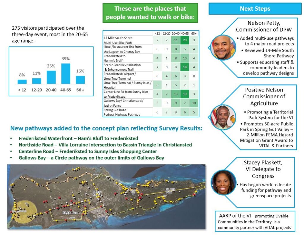
Total Participants = 275 from the beginning to the end of the survey
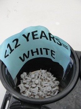
< 12 years = white pins = 23 participants
12-20 years = red pins = 21 participants
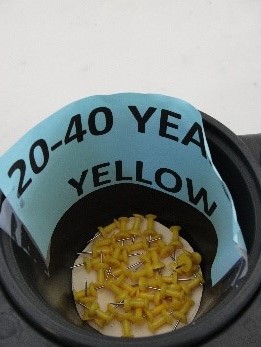
20 – 40 years = yellow pins = 70 participants
40 – 65 years = silver metallic pins = 108 participants
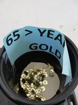
66 > years = gold metallic pins = 43 participants
TRENDS IDENTIFIED
- <12 years represented by the white pins on the map clustered around the Sunny Isles Shopping Center and Movie Theater
- 12 to 20 years represented by the white pins on the map supported a pathway from the Center Line Road from Sunny Isles to Frederiksted.
- 20 to 40 years represented by the yellow pins on the map were evenly distributed throughout the Island with a strong clustering in both Historical Towns, Frederiksted to the West and Christiansted in the East.
- 40 – 65 years represented by the silver metallic pins showed increased concentration on the 14-Mile Scenic Road and the 14-Mile South Shore Pathway locations.
- 65 years > had increased concentration in the Christiansted Town and the Spring Gut Road Areas.
SUPPORTING DATA FOR THE TRENDS
- The Sunny Isles Shopping Center has the Kmart stores, Clothing Shops, Food Venues, open theater and play center along with a new Movie Theater. These venues support young children who accompany parents for items of daily needs.
- This age group are attending schools and have increased freedom of movement. The Center Line Road has the University and High Schools along its route. It also has food vendors, Shopping Malls with 2 Kmart Stores.
- These are young adults who are attending advanced schooling, raising families and working. They are active on weekends and dating plus enjoying water sports and friends. This supports the data of them having access throughout the island.
- This age group has older children or nearing retirement and many people can be seen walking quiet remote areas of the Island such as the Scenic Road and enjoying the Restaurants and waterfront venues in Frederiksted town.
- This age group are mainly retired with some aging issues such as changes to their motor abilities. Many people in February travel to St. Croix from the mainland and enjoy a warm winter. They enjoy the Christiansted Town and remote walking along Spring Gut Road and the Bypass Sidewalk.
NEW LOCATIONS TO CONSIDER PATHWAYS IDENTIFIED FROM THE SURVEY
- There is a multi-age interest for a pathway along the waterfront location from the Frederiksted Town to the Scenic Rd.
- Center Line Rd is the main area on the Island where businesses and schools are located. This area was not chosen due to its proximity to a busy road, however this data supports the need to connect people from communities to services of daily living. Community designs on the Island require residents to leave their location and access the Center Line Rd. in order to move throughout the Island. This is also the shortest route and the most used route to reach destinations. The data suggests that all age groups would like a pathway along this roadway.
SUPPORT FOR VARIED SEGMENTS – (White / Red / Yellow / Silver / Gold)
- 14-Mile South Shore Multi-Use Bike Path = 38 Total Pins (2/2/11/20/3)
- Hotel/Restaurant link from the Lagoon to Chenay Bay = 17 Total Pins (0/0/8/5/4)
- Frederiksted to Scenic Road water-side = 27 Total Pins (4/1/8/10/4)
- Scenic Road 14-Mile Road = 29 Total Pins (2/0/3/19/4)
- Frederiksted/ Airport / Lime Tree Terminal = 13 Total Pins (0/4/6/3/0)
- Lime Tree Terminal / Sunny Isles /Hospital = 15 Total Pins (6/1/5/2/1)
- Center Line Rd from Sunny Isles to Frederiksted = 46 Total Pins (4/7/13/19/3)
- Gallows Bay/ Christiansted / Judith Fancy = 29 Total Pins (3/0/9/7/10)
- Spring Gut Road = 16 Total Points (0/2/3/6/5)
- Miscellaneous (Random hillsides/ Coastlines) = 45 Total Pins (2/2/11/20/3)
- Hotel/Restaurant link from the Lagoon to Chenay Bay = 17 Total Pins (0/0/8/5/4)
- Frederiksted to Scenic Road water-side = 27 Total Pins (4/1/8/10/4)
- Scenic Road 14-Mile Road = 28 Total Pins (2/0/3/19/4)
- Frederiksted/ Airport / Lime Tree Terminal = 13 Total Pins (0/4/6/3/0)
- Lime Tree Terminal / Sunny Isles /Hospital = 15 Total Pins (6/1/5/2/1)
- Center Line Rd from Sunny Isles to Frederiksted = 46 Total Pins (4/7/13/19/3)
- Gallows Bay/ Christiansted / Judith Fancy = 29 Total Pins (3/0/9/7/10)
- Spring Gut Road = 16 Total Pins (0/2/3/6/5)